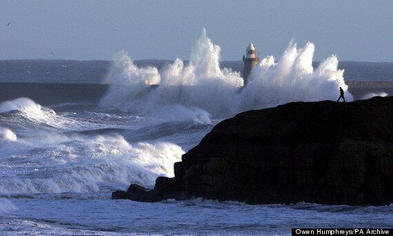
Pockets of the UK have been told to expect some of the worst weather conditions for 30 years, as a combination of gale-force winds and large waves threaten to bring flooding to the east coast.
The Environment Agency and Met Office reckon huge tidal surges could see water levels overtop sea defences.

There are flood risks along the east coast of England
Train operators are already asking commuters to factor potential delays into their journey times, with forecasters predicting 95mph winds and a dusting of snow across parts of the country.
The Environment Agency said areas most at risk include the North Sea coast from Northumberland down to the Thames Estuary and Kent. The tidal reaches of the River Trent, Nottinghamshire, could also be affected.
And on the west coast, from Cumbria down to Cheshire, severe gales and large waves combined with high water levels are also expected tomorrow.
Dr Paul Leinster, Environment Agency chief executive, said: "Gale force winds and large waves along the east coast of England are forecast during Thursday and Friday, coinciding with high tides and a significant coastal surge.
"Flooding of some coastal communities is expected and some defences could be overtopped by the combined effect of high tides, high winds and a tidal surge.
"Coastal paths and promenades will be highly dangerous as there is an increased risk of people being swept out to sea.
"The Environment Agency is monitoring the situation closely, working alongside partners including the emergency services, Met Office and local authorities. Environment Agency teams are out on the ground checking that flood defences and barriers are in good working order, monitoring sea levels and issuing flood warnings."
He said people should check the Environment Agency website or on its Twitter feed for the latest flood outlook.
The Met Office has already issued a flurry of weather warnings, having told people in parts of Scotland and northern England they could face a short, sharp, stormy spell of weather over the next 48 hours.
Story continues after slideshow
A forecaster for MeteoGroup, the weather division of the Press Association, said: "The winds will turn more northerly on Thursday afternoon through Friday bringing cold air down from the Arctic and with that it will also be very unsettled with snow showers.
"Because it is northerly and north-westerly winds, it is largely northern and western Scotland that will get the snow showers but some will get into Northern Ireland, north-west England and north Wales as well.
"It will turn milder at the weekend so I would not expect it to last very much beyond Saturday, Sunday."
England has been largely spared extreme weather so far this winter, though that is expected to change when northerly winds from the Arctic bring freezing temperatures to large parts of the UK with snow showers affecting Scotland, Northern Ireland, parts of northern England, north Wales and the east coast from Thursday.
Temperatures are due to plummet to as low as minus 4C (25F) overnight on Thursday in parts of Scotland with the bitter northerly winds set to leave Britain shivering.
It is likely to bring a certain amount of disruption to transport services.
Network Rail have already braced customers in Scotland and parts of north and eastern England to expect delays.
TOP STORIES TODAY
Robin Gisby, Network Rail's director of operations, said: "As we saw with the recent storm which affected the south of England, being prepared and on top of severe weather is key to helping us resume normal levels of services as quickly as possible.
"We will be monitoring conditions on the ground closely throughout the night and into the morning and will have teams in place to react quickly to any damage caused by the weather.
"We will keep as much of the network open as is possible however the potential extreme nature of the conditions and the impact it could have on our infrastructure means that speed restrictions and other measures are necessary in the interests of the safety of passengers and our staff.
"We are working closely with the train operators and other industry partners to do everything we can to reduce disruption, while also operating a safe network for passengers."