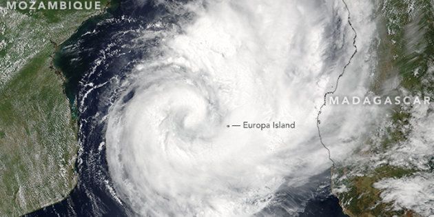
Dineo has lost her vigour and has now been downgraded from a tropical cyclone to a tropical depression. South African Weather Services forecaster Mbavhi Maliage says the storm, which was feared would cause serious damage, is now called Ex Dineo.
"The wind speeds have decreased including its severity. When it started, wind speeds were at 120km/h but they have now decreased to 60km/h," she said.
The storm wreaked havoc in Mozambique as it passed over Inhambane (470km north of the capital Maputo) on Wednesday, with winds of up to 130km/h uprooting trees and blowing roofs off poorly-secured houses.
It is expected to hit the eastern parts of Limpopo, Mpumalanga and KwaZulu-Natal today and still poses a serious threat. Maliage said the rainfall prediction was still high.
"We are expecting 80 percent rainfall over the eastern parts if Limpopo and Mpumalanga. We are expecting about 50mm rainfall over 24 hours with places such as Mopani and Vhembe set to be the most affected in Limpopo," she said.
The government has emergency and disaster management teams on standby. The Cooperative Governance and Traditional Affairs Department has urged South Africans to be vigilant and to stay away from low-lying areas.
Department spokesperson Legadima Leso said even though Limpopo province will be the worst affected, the impact of the storm and heavy rains might also be experienced in other provinces as the rivers flowing from affected areas might lead to flooding somewhere else.
"Government across the three spheres is working on contingency plans to ensure a coherent, integrated and coordinated response. This multi-sectoral plan will assist where the need arises to ensure the safety of communities and to minimise the impact. Even though plans are in place to mitigate the impact of the disastrous conditions caused by the cyclone, government is appealing to all communities in the affected areas to take extra care ahead of this coming cyclone," he said.
Leso said people should follow these steps to ensure they are safe:
- Parents, caregivers and guardians should ensure the safety of their children during the storms. If they are going to school, it is important to ensure that they are safe and do not cross flooded roads, bridges and rivers.
- People are requested not to cross flooded roads, low-lying bridges and rivers. It is important for people not to underestimate the power of moving water, especially flooded rivers.
- If walking outdoors, avoid crossing rivers and swollen streams where water is above your ankles.
- Be especially cautious at night when it's harder to recognise flood dangers.
- Just six inches of fast-moving flood water can knock a person off their feet, and a depth of about half a metre is enough to float a car.
- Never try to walk, swim or drive through fast-moving flood water. Stop, turn around and go another way.
- Listen to the special warnings on radio and/or television.
- Abandon your home immediately, guided by relevant authorities, if evacuation is recommended before access is cut off by flood water.
- Never drive into water covering the road. You do not know how deep it is or if the road has been washed away.
- If the vehicle stalls, leave it immediately and seek higher ground.
