The view from space tells the story of gardens, fields and farms throughout the country. England’s green and pleasant land and Wales’ green, green grass of home turned brown following prolonged dry weather between May and mid-July.
At least it’s not as dry as the summer of ’76, some will say. That summer, the sunniest on record, lives on in the national memory as the benchmark against which all other summers are compared. No, the first half of summer 2018 hasn’t been as dry as 1976.
It’s been drier.
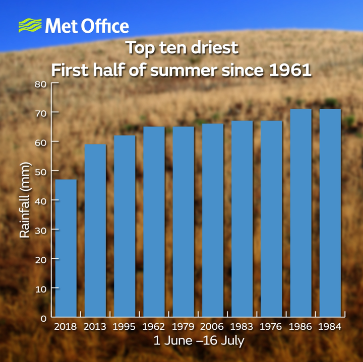
Although UK seasonal and monthly rainfall records stretch back to 1910, the ability to delve into parts of these periods goes back to 1961. By comparing these records, we find summer 2018 so far has been the driest first half of summer since at least 1961. With just 43mm of rainfall across the UK during the past six weeks or so, it has even been drier than the first half of 1995, which eventually became the driest summer on record.

Dry summers all have one thing in common: high pressure. 1976, 1995 and the first half of summer 2018 have all seen high pressure settle and stay over the British Isles, bringing long periods of sunny and warm weather.
With high pressure sitting on top of the UK, the jet stream is diverted north. This fast-flowing current of air circles the globe five miles high in the sky and acts as a conveyor belt for rain-bearing weather fronts. This summer, fronts have been steered away from the UK and towards Iceland – currently enduring its wettest summer for more than a century.
Whilst London received just 1% of its typical June rainfall, Reykjavik had 440% of its average rain for the month. It’s been even wetter elsewhere. Zakynthos in Greece was drenched by more than 11 times its average June rainfall.
A large ridge of high pressure may have persisted over London but a trough of low pressure has lingered near Zakynthos. A highly amplified jet stream is the common thread, curving well to the north of the UK before diving thousands of miles south towards Greece.
A less amplified jet stream, flowing more directly west to east, would have moved these ridges and troughs along more quickly. The mid-latitudes, where the UK sits, are familiar with the changeable weather patterns that result from an energetic jet stream moving west to east. A typical trough-ridge-trough sequence brings rain-sun-rain.
Recently, the highly amplified jet stream has taken the scenic route around the northern hemisphere, meandering great distances north to south like a lazy river. When the jet stream covers more ground south to north, its progression west to east slows. Ridges and troughs become stuck in the same place for days or weeks at a time. Prolonged sunshine for some, prolonged rainfall for others.
The prolonged sunshine in the UK this summer added up to 371 hours by mid-July. Even if summer sunshine and rainfall revert to average for the rest of the season, 2018 would still be in the top five sunniest and the top ten driest on record.

It’s a big if, however. A lot can change in just a few weeks. The second driest start to summer on record was 2013, with just 59mm of rainfall up to the halfway point. When the schools broke up, however, the weather broke down with heavy rain and thunderstorms during the second half of summer.
In 1976, we had to wait a little longer for a change in the weather. Following the dry summer of 1975 and a dry preceding winter, rainfall was in dire need by the end of August. The dry spell broke in spectacular fashion with severe thunderstorms bringing rain to some places for the first time in weeks. September and October 1976 were both very wet months.
Weather patterns may become stuck for weeks or months at a time but rain in the British Isles always returns eventually.
