Just days ago Britain was basking in the hottest September day for more than 100 years but after the heatwave gave way to thunderstorms it has become evidently clear that summer is finally over.
Tuesday was the hottest day of the year so far with a temperature of 34.4C recorded at Gravesend but after Friday’s thunderstorms, many areas of the UK will be feeling far fresher this weekend.
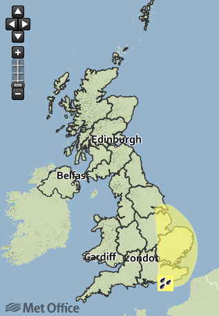
Yellow weather warnings remained in place on Friday for parts of south-east Britain.

The Met Office’s chief forecaster’s comments, valid until 7pm on Friday, said: “Heavy rain and thunderstorms will continue to bring locally torrential downpours today.
“This will bring the risk of 20 to 30 mm of rain in an hour in places, and 40 to 50 mm in a few hours.
“The area of thundery rain will gradually clear eastwards through the day whilst also tending to become less heavy later this afternoon and early evening.”

According to BBC Weather’s John Hammond, temperatures at the weekend will be in the mid to high teens - pretty standard for this time of year.
He said that although there would be no more thundery downpours on Saturday and Sunday, Britons in central and eastern parts of the country can expect “damp, dreary” weather, with things a little better further west.
Most of the country can expect the odd patch of sun and some light winds on Sunday.
A train derailed near Watford Junction after being hit by a landslide caused by flooding on Friday and Didcot Parkway station was submerged by floodwater.
Flash flooding also hit parts of the South East as thunderstorms washed away the recent heatwave, dumping almost half a month’s rain in a few hours.
There were reports of roads and properties being inundated across Surrey, Hampshire, Hertfordshire and Greater London as a band of torrential rain moved in from the Channel overnight, prompting the Environment Agency to issue a series of flood warnings.
Surrey Fire and Rescue Service said it had been called to reports of a house struck by lightning near Woking, while crews worked to pump water out of flooded premises across the county.
Transport for London said two Tube stations in west London were closed due to flooding, while there were reports of disruption on the M4.
