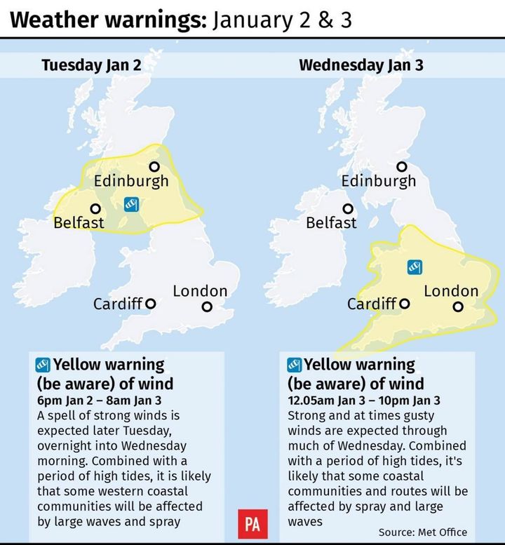
Britain will be buffeted by wind gusts of up to 80mph on Tuesday night as Storm Eleanor heads for the nation’s shores.
The fifth named storm of the season will also bring a “very windy” spell to the on Wednesday too, forecasters said.
The Met Office has issued several national severe weather warnings due to the potential for travel disruption.

Coastal roads and properties along Britain’s western and southern coasts are vulnerable to high waves throwing beach material onto sea fronts, forecasters warned.
Met Office chief forecaster Paul Gundersen said: “The unsettled theme continues throughout this week, with further spells of rain moving across the UK from the west as many return to work on Tuesday and there will again be some snow over the high ground in Scotland.
“The wind will pick up again later on Tuesday and Wednesday as developing Storm Eleanor heads towards the UK and Ireland.”
The Environment Agency warned earlier that strong winds and high tides could bring coastal flooding from Tuesday until Thursday.
Carol Holt, the Environment Agency’s flood duty manager, said: “We urge people to stay safe on the coast – take extreme care on coastal paths and promenades, and don’t put yourself in unnecessary danger trying to take ‘storm selfies’.
“If you’re travelling, please check your route before setting off and don’t drive through flood water.”
A yellow weather warning has been issued for between 6pm on Tuesday and 8am on Wednesday for north east and west England, Northern Ireland and parts of Scotland.
The warning predicts gales with gusts of 60mph to 70mph are likely while some western coastal areas have a chance of seeing gusts of up to 80mph.
Deputy chief forecaster Dan Harris added that next weekend could bring a return of colder conditions with a risk of frost, ice and wintry conditions, particularly in the north.
He added: “It could remain more unsettled in the south.
“The details of the forecast later this week and into the weekend are extremely uncertain at this stage, so my advice is to keep up to date with the latest forecasts as confidence will increase later in the week.”
