UK Weather Forecast: Storm Caroline Prompts Danger To Life Warning

Gusts of up to 90mph expected.
LOADINGERROR LOADING

Forecasters warned of a danger to life on Thursday as Storm Caroline battered Scotland with 90mph winds on Thursday.

The Met Office has issued an amber “be prepared” weather warning as train and ferry services have been suspended in parts of Scotland and schools and nurseries in the Western Isles are closed. According to local media reports more than 4,000 have been left without power.

Scottish police have warned people not to travel unless absolutely necessary.

Take extra care today across Scotland's roads. Consider whether you really need to travel, make sure your mobile phone is charged & that you have sufficient fuel & supplies such as warm clothes, food & water in event you are delayed. Also check @trafficscotland #StormCaroline

— Police Scotland (@policescotland) December 7, 2017

The Met has also issued a snow and ice warning saying by Friday snow showers will become “increasingly frequent” and will extend beyond Scotland, Northern Ireland and northern England to “many other northern and western parts of the UK”.

The heaviest and most frequent snow showers, it said, will be confined in northeast Scotland on Saturday.
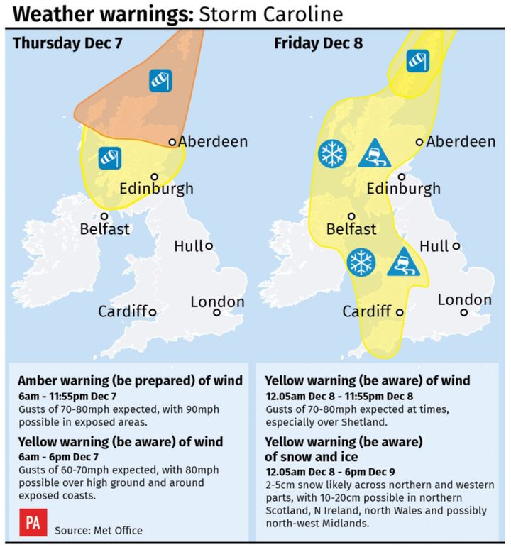
Forecasters have issued a danger to life warning as gusts of 90mph are expected
PA

A Yellow severe weather warning for #snow has been updated: https://t.co/QwDLMfRBfs Stay #weatheraware @metofficeuk pic.twitter.com/4UPsVtC2Kl

— Met Office (@metoffice) December 7, 2017

The #wind is picking up across northern Scotland as #StormCaroline moves in. Stay #weatheraware pic.twitter.com/Uxq9sY7THF

— Met Office (@metoffice) December 7, 2017

UPDATE: Storm Caroline: Severe gales strengthen across Scotland amid school closureshttps://t.co/84LxybnGAj pic.twitter.com/fg0bNE0KqJ

— The Scotsman (@TheScotsman) December 7, 2017

Met Office chief meteorologist Steve Ramsdale said: “The strongest winds will reach the northwest of Scotland early on Thursday, extending to northeast Scotland and the Northern Isles in the afternoon.

“During Thursday winds will start to ease in the west with the strongest of the winds becoming confined to the Northern Isles in the evening.”

The strong wind warning is valid from 6am until 11.55pm on Thursday, with an amber warning for northern Scotland.

Storm Caroline is set to wreak havoc on parts of Britain pic.twitter.com/7R4FkUhPGV

— The Telegraph (@Telegraph) December 7, 2017

#StormCaroline will bring a spell heavy rain and damaging winds with the greatest impacts likely for Scotland and the far north of Northern Ireland on Thursday #weatheraware pic.twitter.com/6hAYRYVcU8

— Met Office (@metoffice) December 6, 2017

Good morning, Storm Caroline will bring storm force winds across Scotland, combined with frequent snow showers. Mild, wet and windy across England and Wales at first, turning brighter and colder later. https://t.co/buNIH9sWMC ^Patrick pic.twitter.com/0PMpDrKjvg

— Met Office (@metoffice) December 7, 2017

We've issued more Flood Alerts and Warnings for the impacts of #StormCaroline - the most up-to-date information is always available at https://t.co/x0aX3QUNFG pic.twitter.com/8fJZH3iGlg

— SEPA (@ScottishEPA) December 6, 2017

Very high winds are expected today, disruption is affecting sailings. Be #WinterReady and check your sailing status before you travel: https://t.co/SB4ZDu0Tim Remember to follow @CalMac_Updates on Twitter and allow for additional travel time to and from our ports.

— CalMac Ferries (@CalMacFerries) December 7, 2017

A yellow “be aware” warning is in force for the southern half of Scotland and parts of the north of Northern Ireland between 6am and 6pm as well.

The Met Office said gusts of 70mph to 80mph are expected widely in northern Scotland, with winds of up to 90mph possible in exposed areas.

It said: “Flying debris is likely and could lead to injuries or danger to life. Some damage to buildings is possible, such as tiles blowing off roofs.

“Large waves are expected and beach material may be thrown onto coastal roads, sea fronts and properties.”

Train services have been suspended between Aberdeen and Inverness, Inverness and WIck, Inverness and Kyle of Lochalsh as well some Glasgow Queen Street routes to the west coast.

⚠️ #StormCaroline. Here’s our Head of Integrated Control, Mark Ilderton, with an update on our plans to deal with tomorrow’s storm. pic.twitter.com/7BbWYq5Puo

— ScotRail (@ScotRail) December 6, 2017

Here is the offending trampoline on the line that caused so many problems earlier. #StormCaroline pic.twitter.com/QXqPvzAzaa

— ScotRail (@ScotRail) December 7, 2017

Scotrail urged people living near tracks to secure any garden furniture and trampolines and shared a picture of an upended trampoline on the tracks.

Scotland’s Transport Minister Humza Yousaf said: “With stormy weather expected across the north of Scotland we would urge people to check with their operators before they travel, especially if they are planning a ferry journey.

“There may also be bridge restrictions, particularly for high-sided vehicles, and we would urge road users to check the latest information on wind thresholds on the Traffic Scotland website to see where this is likely.”

Close

What's Hot